
FLAME University, Pune, has launched The India State Stories, a first-of-its-kind national research and online visual platform, supported by the Centre for Legislative Education and Research, a research hub at FLAME that is dedicated to creating awareness about the legislative process with a focus on India.
The project traces the evolution of India’s states and districts, exploring the historical and political narratives behind the creation and transformation of the country’s administrative boundaries. Combining rigorous academic research with interactive data visualization and storytelling, The India State Stories can now be accessed online, making India’s administrative history accessible to policymakers, researchers, media, and citizens alike.
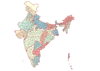
Districts are the backbone of India’s administrative system, acting as a critical interface between states and citizens in the implementation of welfare schemes, development planning, law and order, and political representation. India’s districts have been evolving, from 310 districts in 1951 to over 770+ districts and thousands of subdistricts at present, shaping planning and service. And yet, clear, comparable, and visual data on this evolution has remained a challenge to access.
That was until now. The India State Stories has introduced new, interactive visualizations online, which delve into the fascinating stories of each state and district. From the negotiation and integration process of over 550 princely states post-1947, which fundamentally reshaped the map of modern India, to the ongoing territorial reorganization and renaming, these stories reflect India’s complex cultural, linguistic, and geographical diversity. The digital platform explores the pivotal events, influential personalities, and societal transformations that have made the Indian subcontinent what it is today. It places current governance debates within a historical and policy context, rather than treating district splits as isolated political events.
This project is not a one-time launch. Public policy and administration rarely address the evolution of the ‘district’ in India, and the District Evolution project within The India State Stories does just that. It is a public-interest data resource, available online, that documents districts pan-India from 1872 with periodic tracking of district splits, mergers, and renaming. By asking important questions like “Why are districts split?”, “Who bears the costs and benefits?”, and “Does creating new districts lead to better administration?”, this online platform is an empowering tool that enables journalists and policymakers to decode historical patterns of district formation and assess how administrative restructuring has shaped governance effectiveness, regional inequality, and development outcomes across states and regions.
Speaking on the significance of this research, Prof. Dishan Kamdar, Vice-Chancellor, FLAME University, said, “Through these research initiatives, FLAME University continues its efforts to support evidence-based policymaking, public discourse, and better-informed governance decisions by making this knowledge publicly available to citizens of our country.”
Prof. Shivakumar Jolad, Chair, Centre for Legislative Education and Research, FLAME University, added, “India’s political map is the product of layered processes: colonial administration, the integration of princely states, linguistic reorganization, and subsequent territorial adjustment. At a time when India faces renewed questions around federal balance, delimitation, regional inequality, and administrative restructuring, historical context becomes indispensable. By systematically documenting how states and districts have been made, merged, and reorganized since Independence, the India State Story project provides a critical lens to understand how past territorial choices influence present-day policy, planning, and democratic representation in India. Despite their importance, comparable, longitudinal, and visual data on district evolution hasn’t been easy to access. The India State Stories addresses this critical national data and knowledge gap. It is an ongoing, evolving platform that provides a long-term view of how and why districts have been split, reorganized, and renamed.”
Link to the platform: https://www.indiastatestory.in/
On the platform, you can explore:
- District Evolution: https://www.indiastatestory.in/districtevolution
This is a curated series of 10 research articles that explore district formation across colonial rule, post-independence integration, political motivations, renaming, and district-level inequality.
- District Dashboards: https://www.indiastatestory.in/districtdashboards
They are interactive visual dashboards covering district changes and transitions across three historical phases: 1872 – 1941, 1941 – 1951, and 1951 – 2024.
- District Tracker: https://www.indiastatestory.in/district-tracker
It is an end-to-end interactive mapping of India’s districts, subdistricts, and administrative structures. It also enables comparisons across time, regions, and governance phases.
- Podcast Series: https://www.indiastatestory.in/podcast-1
This ambitious project also comprises Drawn and Redrawn—Making of India’s Internal Boundaries, a multilingual podcast based on Independence and Integration. In 38 episodes across each language, which includes English, Marathi, Kannada, and Hindi, the podcast explores the integration of princely states, boundary negotiations, and administrative consolidation post 1947. Available on both Spotify and YouTube, one can listen to each story on the go.


